Health and Education Determinants (HEAD)
![]() AIM
AIM
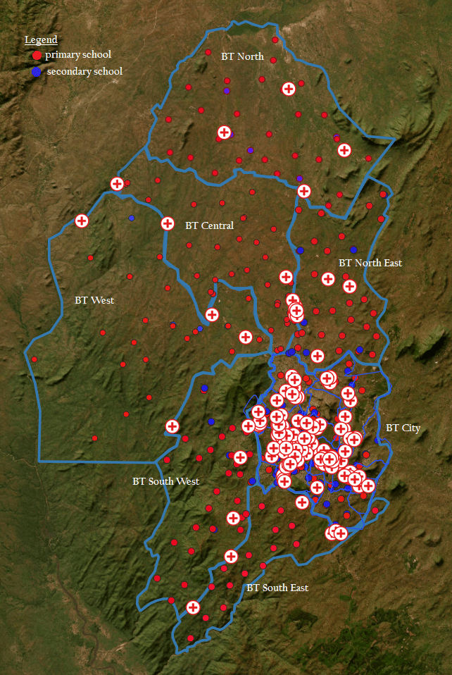
This project seeks to understand the geographical layout of schools and health facilities across Blantyre district by mapping out the locations of these facilities to visualise their distribution patterns. And also measure the distances between schools and the nearest clinics within Blantyre district to assess the accessibility of healthcare services for students and school staff.
![]() OBJECTIVES
OBJECTIVES
- Collect names, school type, ownership status and geographical coordinates of primary, secondary and tertiary schools as well as the health facilities.
- Develop a geospatial dataset mapping schools and health facilities with calculated distances from a school to the next nearest school and health facility within a ward in Blantyre district.
![]() HIGH-LEVEL METHODOLOGY
HIGH-LEVEL METHODOLOGY

This study employed a systematic approach to collect, process, and analyse data related to schools and health facilities in Blantyre district. The schools data was sourced from multiple platforms, including Giga Global and OCHA Services using web scraping and downloading. Schools were categorised into primary, secondary, and tertiary with their type and ownership status information. Schools without coordinates were excluded from the dataset. Health facilities were categorised into hospitals, health centres, dispensaries and clinics with their ownership status such as Government-owned, private and religion owned.
For each constituency in the district, the ward boundaries were georeferenced in QGIS using original demarcation maps sourced from the Malawi Electoral Commission. Separate shapefiles for schools and health facilities were created and distribution patterns were mined using QGIS software. These layers were overlaid to visualise the distribution of schools and health facilities in each ward per constituency. Spatial analysis in QGIS was conducted which involved calculating the number of schools and health facilities in each ward and the distances between schools and their nearest neighbours(school and health facility).
![]() RESULTS
RESULTS
- A geospatial dataset which maps 340 schools(primary, secondary and tertiary) and 146 health facilities in Blantyre district.
- Visualisation of schools, clinics, and major roads on a map using QGIS.
- Insights into the accessibility of healthcare and educational facilities, identifying potential areas for improvement in service delivery and infrastructure.
![]() TEAM
TEAM
Dr. Amelia Taylor
Amoss Robert
Tamanda Phiri
Moses Gwaza
 KAI LAB